GIS (Geographic Information System) is a tool that is improving our world (and our work here at TCE).
GIS is designed to store, manipulate, create, analyze and present spatial or geographic data. While GIS has been around for many years, its uses continue to grow rapidly with technological advances. GIS is used by everyone from the federal government, universities, and large corporations, to small municipalities, and private companies to share and display geographic data.
Apart from the amazing computing power of GIS systems, its use has grown for a few key reasons. One of them is due to the availability of open source public data open to anyone with access to the internet. As well as the ability to easily share information and display datain a way that is both aesthetic and easy to understand. It’s way more user friendly than the classic blue print you might think of. More recently, the ability to create web based interactive maps that allow users to query information from a computer or smart device have come into existence, making GIS even more accessible.
The State of Vermont has online GIS tools! They’re extremely useful, and available for public use. There’s the Vermont Center for Geographic Information (VCGI): http://geodata.vermont.gov/ which has thousands of datasets available for download. It contains everything from tax map parcel lines and topographic maps, to environmental features like soils, streams, and rare species.
The ANR atlas is a State based GIS web app that allows anyone to access the VCGI information as an interactive map, https://anrmaps.vermont.gov/websites/ANRA5/default.html It covers the entire State of Vermont, so you can take a look at your home and see what is going on around you!
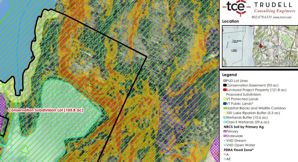
TCE uses GIS on a daily basis to help us with basically every project we work on. We’ve even saved our clients some money on topographic surveys through the use of 1 foot contours and LIDAR information available from these sources.
If you want one of these professionally made maps, call or email us.