 One of the many reasons we love Vermont is our ability to get out in nature and enjoy it. We work hard and play hard! There is no better place (and closer to us) than Catamount Outdoor Family Center right here in our backyard in Williston. Catamount, TCE, and the McCullough family go way back. In the 1970s when Jim McCullough wanted to build a cross country ski center on his family farm, which is also the Governor Chittenden National Historic Site, TCE was there to help. So In 1978, Dick Trudell secured the permit from Act 250, which was still in its infancy back then, having been a landmark piece of legislation. The permit was one page long and issued in a week! We don’t see that any more. Over the years we’ve helped Jim and Lucy with various survey and engineering; so, when they approached TCE in 2016 to help them with conserving the land forever as a Town Forest we jumped at the chance!
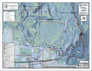
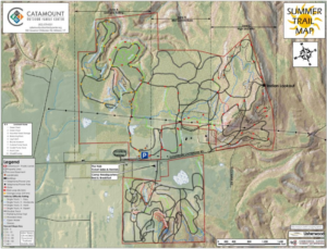
Those dreams are about to become reality and we couldn’t be happier. We did a lot of cool stuff for them to create the Town Forest parcels but our favorite part was getting the chance to create some awesome new trail maps. We were able to use open source GPS data which was collected by mountain bike riders to create GIS based trail maps. Catamount now uses these trail maps for handouts, information kiosks and large format displays to help customers navigate the extensive trail network in the summer and winter. If you haven’t been to Catamount, go! It’s open all year round and enjoy scenery, great vibe, fresh air, exercise and of course, the free maps!